Altyn-Emel

The Dzungarian Gate is a pass in the Dzungarian Alatau mountains along the border between Kazakhstan and the Xinjiang Uyghur Autonomous Region, which for millennia has been considered the only feasible route for invasions between Eurasia and China. It is known for its fierce and almost constant winds. Herodotus in his Histories writes of travelers' reports of a land in the northeast, where griffins guard gold and where the North Wind issues from a mountain cave. This land, Hyperborea, is inhabited by a tribe that is descended from Boreas, the god of Wind, and the snow-nymph, Chione.
Nomadic raiders of the Eurasian Steppe have tended to come pouring in through the Dzungarian Gate. In the 3000 miles of mountain from Manchuria to Afghanistan, going west from China (or Mongolia) you must pass either north of the Tien Shan through Dzungaria, or south of the Tien Shan through the Taklamakan desert and the Tarim Basin. Trading caravans usually took the southern route and nomadic raids the northern - because the Tarim leads to Ferghana Valley and Iran, while Dzungaria leads only to open steppe. The difficulties with the southern route were in the high mountains between the Tarim Basin and Ferghana Valley. The Taklamakan, however, was too dry to support grass, and therefore lacked nomadic hordes likely to rob caravans, while Dzungaria had a fair grazing, few towns to base soldiers in, and no significant mountain obstacles once you passed the Gate. Therefore, the trade went south and invasions took the northern route.

These invasions were by no means one-directional from east to west; we read a poem composed in the early 11th century, preserved in the Diwan Lugat at-Turk, "in which Muslim Turkic, presumably Qarakhanid, troops carry out a raid on the Uighurs beyond the Ili River and despoil their Buddhist temples:
Qudruq qatiy tügdümiz
tänrig üküs ögdümiz
kämsip atiy tägdimiz
aldap yana qactimiz
We tied the horses' tails securely; we praised God Most High greatly (meaning the cry of allahu akbar aong the heathen ranks); we attacked them driving the horses, and then feigned flight (that they would come after us and we might turn on them and rout them.)"
(From The Šabdan Baatır Codex: Epic and the Writing of Northern Kirghiz History edited by Dan Prior. The agglutinative aspects of such bellicose chants were not lost on Tolkien as he formulated Black Speech - Ash nazg durbatulûk ...)

The British journalist and MP M. Philips Price - Eastern Front correspondent in WW I, witness to the Bolshevik Revolution, traveler in Dzungaria c. 1910 wrote:
One can picture the Dzungarian Gate in the Ice Age: a narrow strait through which the Arctic-AraloCaspian Sea ebbed and flowed into the seas of Central Asia, scoured by icebergs descending from ancient glaciers on the Ala-tau and Barlik Mountains and forested perhaps down to the water's edge,—not unlike the Straits of Belle Isle at the present day. Now a change has been wrought; earth-movement has drained the sea. But away to the north there still remain the lakes of Ala Kul, Sasik Kul, and Balkash, and on the south Ebi Nor,—pools left in the desert—all that remains of the great icy sea. The alluvial plains, once its bed, are now covered by desert grasses, while the forest clings only to the shaded slopes and gullies on the northern slopes of the mountains.
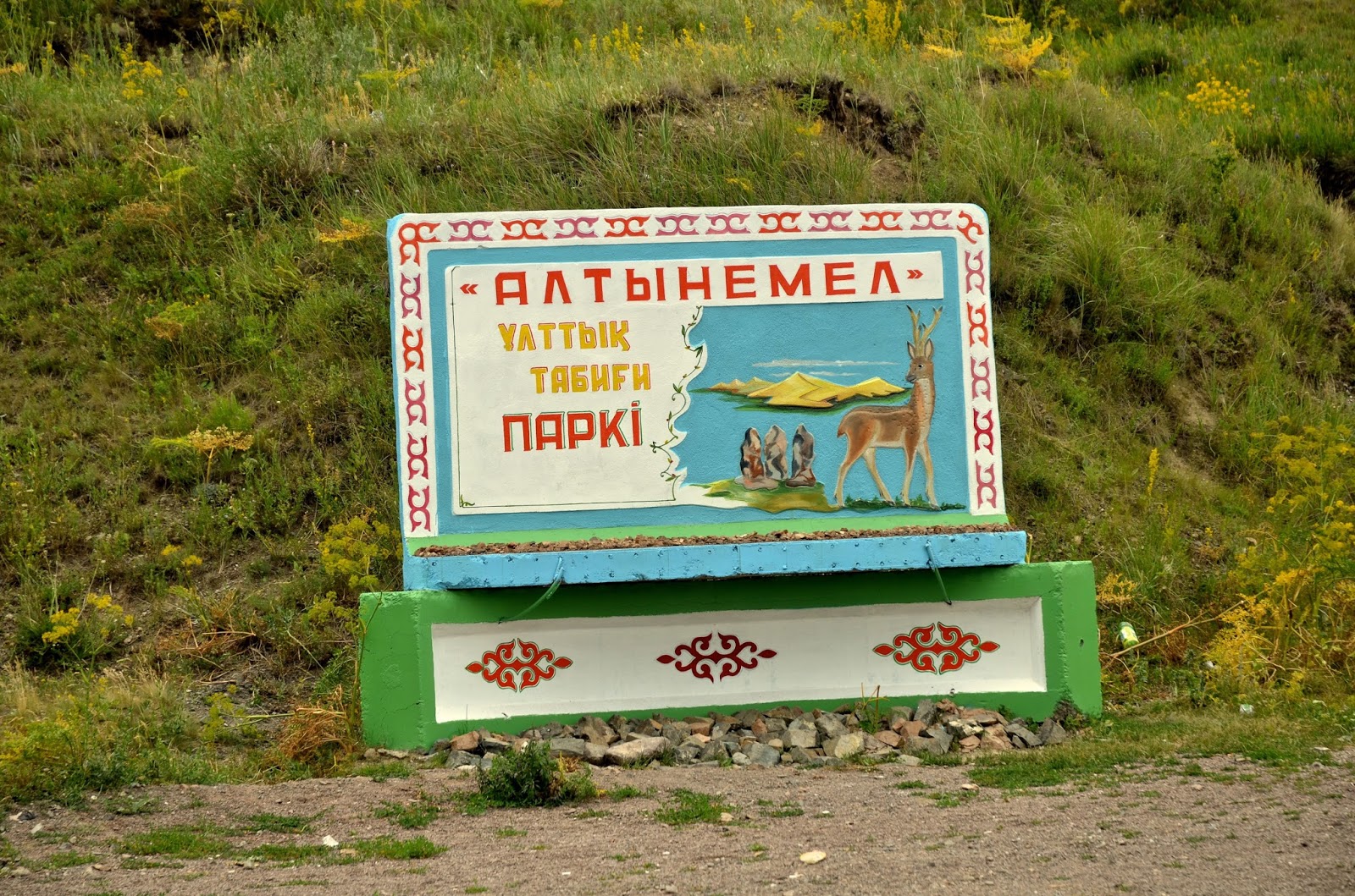
Past the Dzungarian Gate, the Dzungarian Alatau gets three names from West to East: Degeres, then Altyn Emel, then Koyandytau. In 1218-19, when Chingis Khan started his rampage through Eurasia, he came in through the Dzungarian Gate. (For the casus belli, see Juvaini.) As he passed the spurs of the Alatau, he was struck by a vista of golden grass against the setting sun on a ridge between two peaks - he named it Altyn-Emel, the Golden Saddle. The area is one of Kazakhstan's largest national parks today, covering nearly 5000 sq kms, between the Tien Shan and the Alatau.
This is the best place in Central Asia to see certain rare ungulates - the goitered gazelle, the kulan wild ass, Bukhara deer, Przhevalsky horse. Below, one of the rare arkhar (ovis orientalis vignei), also known as the urial or shapo, a rare Central Asian big-horn wild sheep, a red-brown cousin of the argali that used to range from Ladakh to Siberia, but it now confined to pockets in its former range.

The village housing the park headquarters, Basshi, or Baschi, is the gateway to Altyn-Emel. We are put up in a local guest house, peaceful with a big garden: apricot falling off trees, crunchy apples just ripening, purple pears halfway there, the front gate decked with a trellis of grape vine, and yurts across the street. The manageress has no English, but she beams us smiles showing a mouthful of gold every time she bustles by, carrying all the home-made jam you'd care to eat. Outside, late summer is blazing; once evening falls, they fill the cattle-trough with water for naked children to splash in, as the mothers sit demurely dipping their feet.

The park is famous for the Singing Dune, which hums like an aircraft engine in the right conditions. The wind from the Dzungarian gate maintains this barchan dune, 2km long and 120m high, in a funnel of flat-land bounded by the Ili River to the south, the Ulken Kalkan spur to the east and Kishi Kalkan to the west. If you slide down, the dune emits a loud humming noise, often likened to that of a church organ, or droning aircraft. The generation of noise is related to the movement of the sand: scientists debate whether the it is the resonant movement of air between the grains, or discharge of static electricity. Local legend offers a different cause: that the noise is from the delight of the evil spirit Shaitan, working through a part of Chingis Khan's army that was lost and is buried beneath the sands.
Below, we brave the 40 degree heat, the shifting sand, and the hyperborean winds to slide down the Singing Dune of Altyn-Emel.

0 Comments:
Post a Comment
<< Home